Dubai Metro Map 2025 Your Complete Route Guide
Ever found yourself lost in the lively streets of Dubai while trying to figure out which metro route to take? No need to worry. The Dubai Metro Map is your perfect companion for exploring the city with ease and confidence. This comprehensive and easy-to-read guide highlights every station, line, and interchange, helping you plan the most efficient and comfortable route to your desired destination. Whether you are a visitor or a daily commuter, this map ensures your journey across Dubai is seamless and stress-free.
Whether you like having a printed copy from metro stations or prefer downloading the digital version from the official RTA website, the Dubai Metro Map remains an essential travel companion. You can conveniently explore and track the routes for the Red Line, Green Line, and Tram Line right here.
Dubai Metro Map 2025
The Dubai Metro, a vital component of the city’s public transportation network, has continued to grow and develop since it was first introduced.
Here’s an overview of the Dubai Metro system as of 2024:
Dubai Metro Lines and Extensions
- Red Line:
- Opened: 9 September 2009
- Number of Stations: 35
- Key Extensions: The Expo 2020 extension, which became fully operational in 2021, extended the Red Line’s coverage to include the Expo 2020 site, now called Expo City Dubai.
- Green Line:
- Opened: 9 September 2011
- Number of Stations: 18
- Station Availability: At first, a few stations were not in operation, but by March 1, 2014, all stations along the Green Line were fully opened to the public.
Future Plans
Both the Red and Green Lines are set to undergo further extensions to cover more areas across the city. New lines are also planned to meet the needs of Dubai’s growing population and its continuously expanding urban landscape.
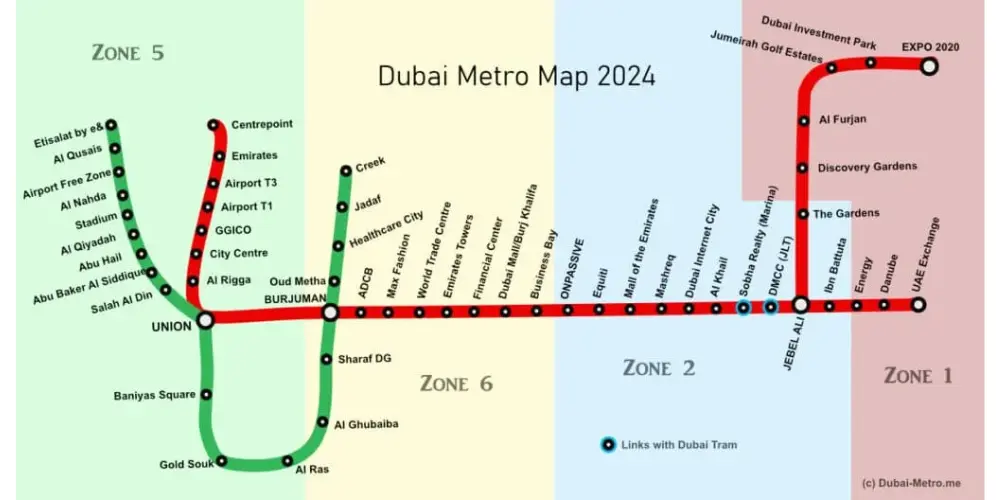
Dubai Metro Zones
The Dubai Metro network is organized into four primary zones, forming part of a broader fare structure that includes a total of seven zones. Fares are calculated according to the distance traveled across these zones, which are as follows:
- Zone 1: Central Dubai areas
- Zone 2: Surrounding central areas
- Zone 3: Outlying suburban areas
- Zone 4: Farther areas extending towards the outskirts of the city
Ticketing and Fares
The fare structure depends on the number of zones you travel across. The main ticketing options available are:
- Single Journey Tickets: Priced based on the number of zones crossed.
- Nol Cards: Rechargeable cards that offer discounts and convenience for regular travelers.
- One Day Pass: Allows unlimited travel across all zones for a day.
- Monthly and Yearly Passes: For frequent travelers, these passes offer cost savings and convenience.
Fares increased in November 2014 following the launch of the Tram service; however, they have remained reasonably and competitively priced.
For the latest updates on fares, route extensions, and newly added lines, it is recommended to visit the official Dubai Metro news page and the Dubai Metro Tickets page.
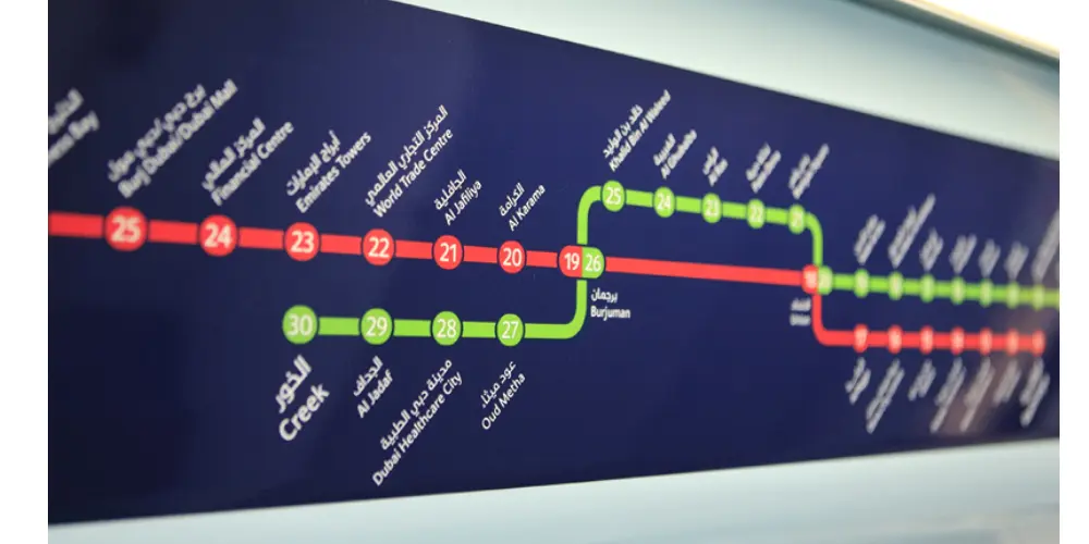
The Dubai Metro Map Red Line
| Station Code | Station Name |
| R11 | Centrepoint |
| R12 | Emirates |
| R13 | Airport Terminal 3 |
| R14 | Airport Terminal 1 |
| R15 | GGICO |
| R16 | City Centre Deira |
| R17 | Al Rigga |
| R18 | Union |
| R19 | Burjuman |
| R20 | ADCB |
| R21 | Max |
| R22 | World Trade Center |
| R23 | Emirates Towers |
| R24 | Financial Centre |
| R25 | Burj Khalifa / Dubai Mall |
| R26 | Business Bay |
| R29 | ONPASSIVE |
| R31 | Equiti |
| R32 | Mall of the Emirates |
| R33 | Mashreq |
| R34 | Dubai Internet City |
| R35 | Al Khail |
| R36 | Sobha Realty |
| R37 | DMCC |
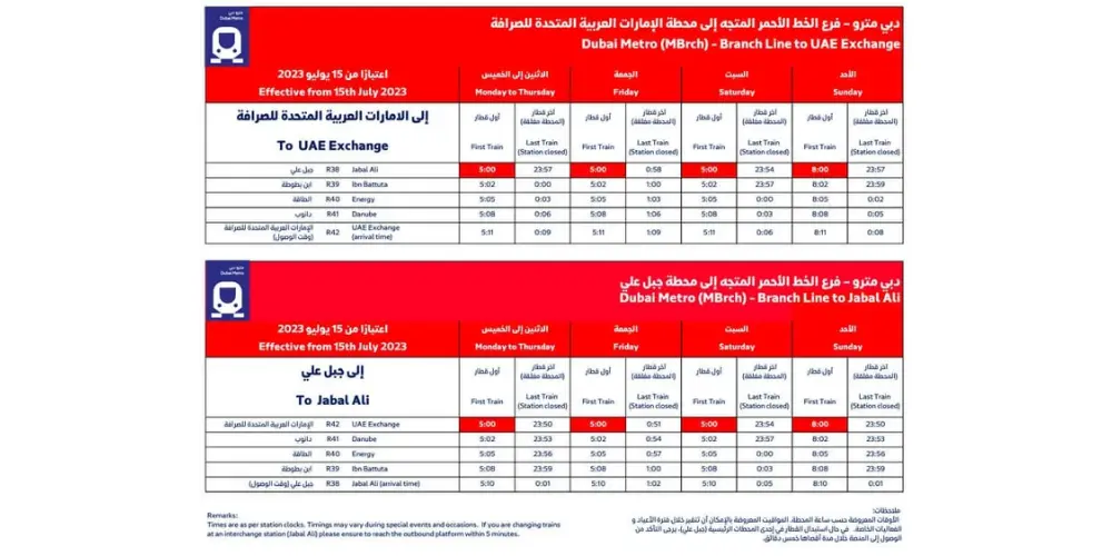
| R38 | Jebel Ali |
| R39 | Ibn Battuta |
| R40 | Energy |
| R41 | Danube |
| R42 | UAE Exchange |
| R70 | The Gardens |
| R71 | Discovery Gardens |
| R72 | Al Furjan |
| R73 | Jumeirah Golf Estates |
| R74 | Dubai Investment Park |
| R76 | EXPO 2020 |
The Tram Line
The Green Line extends across five distinct zones, with a strong focus on showcasing Dubai’s rich historic and cultural areas. It provides smooth and convenient connections between popular destinations, including Jumeirah Beach, Dubai Marina, Palm Jumeirah, and Al Sufouh, making it an essential route for both residents and visitors.
| Zone | Station |
| 01 | Jumeirah Beach Residence 1 |
| 02 | Jumeirah Beach Residence 2 |
| 03 | Jumeirah Lakes Towers |
| 04 | Dubai Marina Mall |
| 05 | Dubai Marina |
| 06 | Marina Towers |
| 07 | Mina Seyahi |
| 08 | Media City |
| 09 | Palm Jumeirah |
| 10 | Knowledge Village |
| 11 | Al Sufouh |
The Green Line
The Green Line covers five major zones, primarily serving Dubai’s historical and cultural districts. It connects key stations such as Etisalat, Al Qusais, Union Station, Al Fahidi, and Creek, offering convenient access across the city’s heritage areas.
| Code | Station |
| G11 | Etisalat by e& |
| G12 | Al Qusais |
| G13 | Dubai Airport Free Zone |
| G14 | Al Nahda |
| G15 | Stadium |
| G16 | Al Qiyadah |
| G17 | Abu Hail |
| G18 | Abu Baker Al Siddique |
| G19 | Salah Al Din |
| G20 | Union |
| G21 | Baniyas Square |
| G22 | Gold Souq |
| G23 | Al Ras |
| G24 | Al Gubaiba |
| G25 | Sharaf DG |
| G26 | Burjuman |
| G27 | Oud Metha |
| G28 | Dubai Healthcare City |
| G29 | Al Jadaf |
| G30 | Creek |
To get a clear visual overview of all Dubai Metro stations, you can visit the official RTA website and check the Dubai Metro timings section. There, you’ll find the complete Dubai Metro Map, making it easy to explore routes, connections, and station details before you travel.
Conclusion
With your NOL card ready and the Dubai Metro Map as your trusted companion, you are fully prepared for a smooth and worry-free journey through Dubai. Choose whichever format suits you best, whether digital or printed, and say goodbye to any travel confusion. Enjoy the comfort of the metro system and take in the breathtaking beauty of Dubai’s cityscape. Safe travels and happy exploring.